Modern name:
Tell Abu Shahrayn
Ancient name (if known):
Eridu
Geographic coordinate:
30°48′57.02″N – 45°59′45.85″E
38R NV 95440 MGRS 09672
Governatorate – District – Sub-district:
Dhi-Qar – Nasiriyah – al Bathaa
Nearest City:
25 km south-west of Ur (but it needs at least 45 minutes to be reached – see Accessibility); 17 km ca. from Obeid; 40 km ca. south-west from Nasiriyah.
Chronological frame:
Ubaid period (from 5500 BC), probably deserted by 1800 BC.
Excavations:
The site at Tell Abu Shahrayn was initially excavated by J.G. Taylor in 1855, by R. Campbell Thompson in 1918, and by H.R. Hall in 1919. Excavation there resumed from 1946 to 1949 under F. Safar and S. Lloyd of the Iraqi Directorate General of Antiquities and Heritage. Currently, the Iraqi authorities have granted permission to excavation of this site to an Italian-Iraqi mission under the direction of Franco D’agostino (Assyriologist of Sapienza, University of Rome) and Marco Ramazzotti (Archaeologist of Sapienza, University of Rome)
Historical Remarks:
A truly ancient city, regarded by the Sumerian scribes as the oldest in the world, where “kingship first came from heaven”. Eridu was reputedly founded by Enki, the Sumerian god of fresh waters and wisdom, who warned Ziusudra, the Sumerian Noah, about the flood. It was probably founded close to the Persian Gulf near the mouth of the Euphrates, but with the accumulation of silt over the centuries, the remains are now some distance from the Gulf.
Despite being the location of the very first dynasty, the city’s importance was always more religious than political. Excavations have uncovered 18 building levels of the remains of the Temple of Enki, the earliest (circa 5500 BC) consist of a 12- by 15-foot room, with an altar or offering table, and a niche for the god’s statue, features that endured throughout Mesopotamian temples. The Temple was rebuilt in subsequent levels on a more ambitious plan, consisting of a central sanctuary and projecting lateral wings, the tripartite plan, which became the characteristic architectural form for Mesopotamian temples.
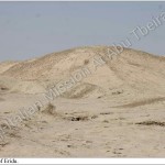
By the Early Dynastic period, Eridu probably had an area of 8-10 hectares and reached its greatest size during the Third Dynasty of Ur, whose kings built a Ziqqurat. Today the eroded platform stands only about 30 feet high, but clearly the base of 150-200 feet supported a much higher superstructure.
Present Situation:
At least 2/3 of the way to the Tell (so-called “ar-rafayya”) are not paved and a four-wheel traction car is needed. The street goes along a military camp used by the Iraqi Army to train soldiers (shooting range). Moreover it is necessary to pass near a petrol station.
No road-sign informs the visitors of the presence of an archaeological site of such importance and it appears to be in the middle of nowhere. This means that no indication, no rest places for tourists are placed in the area.
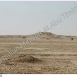
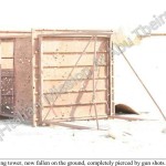
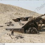
Today the site is quite abandoned. On the surface of the Tell, which lacks any kind of protection or fence, it is possible to find not only rubbish, modern bricks, plastic bags and bottles, paper and so on, but also the remains showing the long period of war which characterized the last ten years of Iraqi history. Beyond bullets and part of bombs, the worst impression is given by the rests of a destroyed tank, which is slowly corroding a few dozen meters from the Ziqqurat, and a metal watching tower, now fallen on the ground, completely pierced by gun shots.
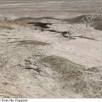
The elevation of the Ziqqurat is still impressive, nevertheless it is quite eroded by the weather conditions (only few brick in place are still visible).
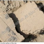
Notwithstanding all this, the visit is highly interesting giving the presence of heaps of pottery sherds left there by the archaeological mission which worked in the site and the possibility of discovering on the surface of the Tell and near the Ziqqurat many examples of inscribed bricks, mainly relating to the Third Dynasty of Ur (2100-2000 a.C.).
Accessibility:
Since the last visit some months ago, the situation of the unpaved street leading to Eridu seems to be worsen. As said above, it needs at least 45 minutes to drive the 25 km from Obeid to the site.
Visibility:
Even if the multi-millennial history of the Tell can be inferred by the great number of pottery sherds on the surface of the site, no structure is visible today (apart from a little portion of a brick wall of the Ziqqurat). The touristic potential of the site is huge but it needs a rehabilitation of the archaeological remains and the creation of information points and rest places for tourist.
Nome moderno:
Tell Abu Shaharyan
Nome antico:
Eridu
Coordinate Geografiche:
30°48′57.02″N – 45°59′45.85″E
38R NV 95440 MGRS 09672
Governatorato-Distretto-Subdistretto:
Dhi-Qar – Nasiriyah – al Bathaa
Città più vicine:
25 km a sud-ovest di Ur (ma è necessario almeno 45 minuti per essere raggiunta – vedi Accessibilità); 17 km ca. da Obeid; 40 km ca. a sud-ovest di Nassiriya.
Quadro Cronologico:
Periodo Ubaid ( dal 5500 a. C.) probabilmente abbandonata dal 1800 a.C.
Scavi:
Il sito di Tell Abu Shahrayn è stato inizialmente scavato da JG Taylor nel 1855, da R. Campbell Thompson nel 1918, e da HR Hall nel 1919. Gli scavi sono stati ripresi dal 1946 al 1949 sotto F. Safar e S. Lloyd della Direzione Generale Irachena delle Antichità e del Patrimonio. Attualmente le autorità Irachene hanno concesso il permesso di scavo ad una missione Italo-Irachena sotto la direzione di Franco D’agostino (Assiriologo dell Sapienza, Università di Roma) e Marco Ramazzotti ( Archeologo della Sapienza, Università di Roma)
Note Storiche:
Una vera città antica, considerata dagli scribi sumeri come la più antica del mondo, dove ” la regalità per la prima volta è scesa dal cielo”. Eridu è stata presumibilmente fondata da Enki, il dio sumero delle acque dolci e della saggezza, che avvertì Ziusudra, il sumero Noè, del diluvio. E ‘stata fondata probabilmente vicino al Golfo Persico nei pressi della foce del fiume Eufrate, ma con l’accumulo di limo nel corso dei secoli, i resti sono ora ad una certa distanza dal Golfo.
Pur essendo l’ubicazione della prima vera dinastia, l’importanza della città è sempre più religiosa che politica. Gli scavi hanno portato alla luce 18 livelli di costruzione dei resti del Tempio di Enki, la prima (circa 5500 a.C) comprende una sala da 12 a 15 piedi, con un altare o tavolo per l’offerta, e una nicchia per la statua del dio, caratteristiche che sono rimaste per tutti i templi mesopotamici. Il tempio fu ricostruito in livelli successivi su un piano più ambizioso, che consiste di un santuario centrale e sporgenti ali laterali, la pianta tripartita, che divenne la forma architettonica caratteristica per i templi della Mesopotamia.
Per il periodo Protodinastico, Eridu probabilmente aveva una superficie di 8-10 ettari e ha raggiunto la sua massima dimensione durante la Terza Dinastia di Ur, i cui re hanno costruito una Ziqqurat. Oggi la piattaforma erosa si erge solo di circa 30 piedi, ma chiaramente la base di 150 – 200 piedi supportava una sovrastruttura molto più elevata.
Situazione attuale:
Almeno 2/3 della strada per il Tell (cosiddetto “ar-rafayya”) non è asfaltata ed è necessaria una macchina a quattro ruote motrici. La strada costeggia un campo militare usata dall’esercito iracheno per addestrare i soldati (range di tiro). Inoltre è necessario passare vicino a una stazione di benzina.
Nessun cartello stradale informa i visitatori della presenza di un sito archeologico di tale importanza e dunque sembra essere in mezzo al nulla. Ciò significa che nessuna indicazione, nessun luogo di sosta per i turisti sono collocati nella zona.
Oggi il sito è piuttosto abbandonato. Sulla superficie del tell, che manca di qualsiasi tipo di protezione o recinzione, è possibile trovare non solo spazzatura, mattoni moderni, sacchetti e bottiglie di plastica, carta e così via, ma i resti mostrano anche il lungo periodo di guerra che ha caratterizzato gli ultimi dieci anni della storia irachena. Al di là di proiettili e pezzi di bombe, l’impressione peggiore è data dai resti di un carro armato distrutto, che a lentamente si sta corrodendo a poche decine di metri dalla Ziqqurat, e una torre di guardia di metallo, ora caduta a terra, completamente trapassata dai colpi di pistola.
L’elevazione della Ziqqurat è ancora impressionante, tuttavia è molto erosa dalle condizioni meteorologiche (solo alcuni mattoni sono ancora visibili al loro posto).
Nonostante tutto questo, la visita è di grande interesse che dà la presenza di cumuli di frammenti di ceramica lasciate dalla missione archeologica che ha lavorato nel sito e la possibilità di scoprire sulla superficie del tell e vicino la ziqqurat i molti esempi di mattoni iscritti, principalmente relativi alla terza dinastia di Ur (2100-2000 a.C).
Accessibilità:
Dall’ultima visita di qualche mese fa, la situazione della strada sterrata che porta ad Eridu sembra peggiorare. Come detto sopra, sono necessari almeno 45 minuti per guidare i 25 km da Obeid al sito.
Visibilità:
Anche se la storia plurimillenaria del tell si può dedurre dal grande numero di frammenti di ceramica sulla superficie del sito, nessuna struttura è visibile oggi (a parte una piccola porzione di un muro di mattoni della Ziqqurat). Il potenziale turistico del sito è enorme, ma ha bisogno di una sistemazione dei resti archeologici e la creazione di punti di informazione e luoghi di sosta per i turisti.
